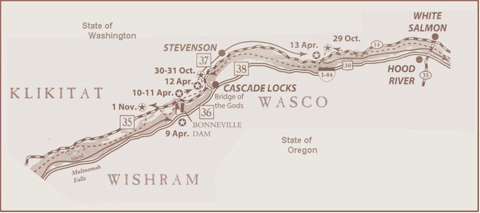
 35.
Beacon State Park - Clark described this "remarkable high
detached rock... about 800 feet high and 400 paces
around, we call the Beaten rock". At this point,
the Corps first noticed tidal influence of the Pacific
Ocean. Trail to summit and spectacular view.
Interpretive sign.
36. Bonneville Dam
-
Completed in 1938, this dam inundated the "Cascades of the Columbia",
around which the Corps portaged. Hatchery, trails, and visitor
center with an exhibit: Lewis & Clark on the River.
37.
Columbia
Gorge Interpretive Center -
Overlooking the river, the museum has Lewis & Clark related exhibits,
the Emory & Ruth Strong Library, and a multi-media presentation on the
history of the Columbia Gorge.
38. Cascade Locks Marine Park
- At the Cascades of the Columbia, now under water, the Captains
observed evidence of a massive landslide that had once blocked the river
and gave rise to the myth of "The Bridge of the Gods".
Interpretive sign, trail and museum. Map Source: Lewis & Clark Bicentennial in
Oregon 1200 SW Park, Portland, OR 97205. Ted Kaye
& Roger Cooke.
|