|
|
|||||
Whether you're planning a weekend getaway or a week-long vacation, LewisandClarkTrail.com is your online connection for Hotel Reservations. Still planning your trip? Check out the events calendar, read travel stories, then finish planning your trip by booking your hotel. LewisandClarkTrail.com invites you to locate the Hotel that meet your travel needs. Thank you & travel safely.
|
|||||
|
|
|||||
|
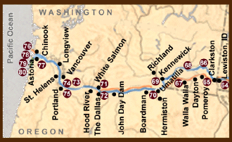
65.
Chief Timothy State Park
- Major interpretive center
devoted to the Expedition and its contacts with Indians in nearby villages (Washington).
Back to Oregon Map 66. Boyer Park - Major recreation complex and marina. Interpretive sign (Washington).
Back to
Oregon Map 67. Lewis and Clark Trail State Park - Interpretive sign (Oregon).
Back to
Oregon Map 68. Lyons Ferry State Park - Major recreation complex and marina. Interpretive sign. In 1964 a Jefferson peace medal given by Lewis and Clark to an Indian chief was found in an Indian grave at the mouth of "Drewyers" (Palouse) River (Washington).
Back to
Oregon Map 69. Sacajawea State Park - Important interpretive center devoted to the Expedition and the role of Sacagawea. (Park uses popular but incorrect spelling "Sacajawea.") (Washington)
Back to
Oregon Map
70.
Hat Rock State Park
- Hat Rock was named by Clark on
October 19, 1805. Interpretive sign (Oregon).
Back to
Oregon Map 71. Horsethief Lake State Park - Site of Expedition’s portage around the "Great Falls" of the Columbia. Interpretive sign (Washington).
Back to
Oregon Map 72. The Dalles - The treacherous "Great Falls" (Celilo) and currents of the "Long and Short Narrows" (all now inundated) were formidable navigational barriers encountered by Lewis and Clark. Interpretive marker at site of the Expedition’s "Rock Fort" camp (Oregon).
Back to
Oregon Map 73. Bonneville Dam - Visitor centers at the dam in both Oregon and Washington interpret the Expedition (Oregon).
Back to
Oregon Map 74. Beacon Rock State Park - Beacon Rock was named by Clark in his journal for November 2, 1805. It was here that they first observed Pacific Ocean tidewater (Washington).
Back to
Oregon Map 75. Lewis and Clark State Park - Self-guiding trail interpreting plants credited to Lewis and Clark for botanical discovery. Interpretive sign (Oregon).
Back to
Oregon Map
76.
Lewis and Clark Interpretive Center - Major interpretive center
devoted to a comprehensive overview of the Expedition. Located on the site where the
Expedition achieved its principal goal - the Pacific Ocean (Washington).
Back to Oregon Map 77. Fort Clatsop National Memorial - Replica of the Expedition’s 1805-06 winter quarters. Visitor center (Oregon).
Back to
Oregon Map
78.
Salt
Works - Site of salt-making camp where Expedition members boiled sea water for 2
months to make 4 bushels of salt for use at Fort Clatsop and on the return journey. In
Seaside, Oregon (Oregon).
Back to Oregon Map 79. Ecola State Park - On January 7-8, 1806, Clark and 14 other crossed over "Clark’s Mountain and Point of View" (Tillamook Head) on their way to the site of a beached whale. A 7.5-mile hiking trail retraces their route (Oregon).
Back to Oregon Map 80. Les Shirley Park - Near mouth of Ecola Creek where whale washed ashore and blubber was purchased from Indians by Clark. Interpretive sign (Oregon). |
|||||


