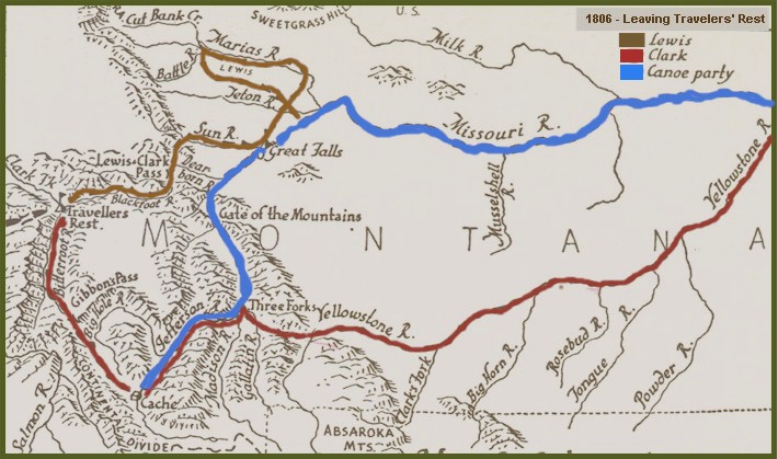
Leaving Travelers' Rest 1806
Exploration routes of Lewis, Clark & canoe party
Clark's
Journal Entries >>
CLARK EXPLORES YELLOWSTONE
At Travelers' Rest, on July 3rd, the party separated. Clark
with 50 horses, 20 men, Sacagawea and her baby, headed up the Bitterroot
River to the place they had met the Flatheads the year before.
They then crosses the Continental Divide at Gibbon's Pass, crossed the
head of the Big Hole valley, in a south-easterly directions, passing a
place where the Indians had recently been digging roots, stopped at a
hot springs, and then crossed Big Hole Pass and arrived at Camp
Fortunate on July 8. Here they recovered their dugouts and the
supplies which had been cached the year before.
After reaching the Three Forks, Sergeant John Ordway and nine men
continued down the Missouri with the dugouts. Clark and the rest
of the party headed east along the Gallatin River on to explore the
Yellowstone River.
Lewis' Journal Entries >>
LEWIS EXPLORES THE MARIAS
From Travelers' Rest, Lewis and nine men headed down the Bitterroot
River to the Clark Fork. They crossed that river and headed
upstream to Blackfoot River, which they ascended, following the route to
the plains used by Nez Perce on their buffalo hunts.
On July 6, they crossed "the prairie of the knobs", Lewis
identified the path they were following as a warpath of the Hidatsas.
They passed passed the remains of many Indian lodges, and crossed the
Continental Divide at Lewis and Clark Pass, and the next day saw the
first buffalo since entering the mountains a year earlier.
Two days later they reported seeing 10,000 buffalo in a 2-mile
circle. They reached Sun River and followed it to their upper
portage camp at Great Falls.
On July 16, Lewis and three men set out overland from the Great Falls
to explore Marias River. They wanted to see if it reached 50
degrees north, thus determining the northern boundary of the Louisiana
Territory, and satisfying the conditions of the 1783 U.S. Treaty with
England.
July 18th, Lewis' party reached the Marias. Three days later
they reached the headwaters of the Marias and headed up the northern
branch (Cut Bank River). They finally came to a place where they
could see the river exiting from the mountains. Because the river
did not reach 50 degrees north, Lewis named the camp "Camp
Disappointment".
On party's return to the Missouri River they met eight Blackfeet
Indians. The Indians camped with Lewis's party on Two Medicine
River. During the night a fight ensued and two Blackfeet Indians
were killed.
Lewis's party made a hasty retreat to the Missouri River where they
had the good fortune of meeting the boats coming down the river from the
Great Falls ( Ordway's party).
Source: US Forest Service
Map Source: The Journals of Lewis & Clark - Edited by Bernard DeVoto
|